Is This Useful? - Google Street View
 A while back I posted about interesting maps (actually in 2005!) and listed out all the interesting map sites. At the time, Amazon's maps.a9.com was the most innovative because they had street level imagery. They've since shut down, but today Google Maps took it to the next level with Google StreetView.
Not sure why you'd want to watch a blurry video rather than just going there, but you can see a demo on YouTube if you like.
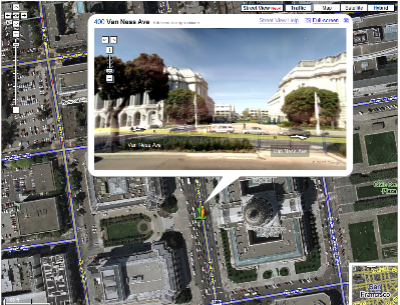
The embedded Flash has a nice draggable cylinder view like QuickTime VR, letting you see any angle stitched together.
The user interface is pure brilliance. Pick up the little yellow man and drag him, and his little feet float in the wind as you drag him round, until he's firmly planted on virtual ground again. A green arrow indicates which direction he's facing. Even arrow keyboard hotkeys work as they should!
Here's the real question - is this useful?
About Scott
Scott Hanselman is a former professor, former Chief Architect in finance, now speaker, consultant, father, diabetic, and Microsoft employee. He is a failed stand-up comic, a cornrower, and a book author.
About Newsletter

 David Sterry

http://maps.google.com/maps?f=q&hl=en&q=2967+geary+ave,+san+francisco&sll=37.783638,-122.452519&sspn=0.007479,0.014591&ie=UTF8&om=0&layer=c&cbll=37.781965,-122.450769&ll=37.785792,-122.450545&spn=0.007479,0.014591&z=16&cbp=1,134.527972027972,0.593411135389219,1

Is it useful? Meh. The people on the Channel 9 video make some arguments for how it is useful to be able to see buildings from street-level so you can use landmarks to find things, but unless you can provide street-level information for every city in North America with 100,000+ population, how useful is it really? If I can't rely on being able to use street-level landmarks everywhere I go, I probably won't use it at all.
You also have to consider the cost of doing this for every major city in the United States and the business case for potential revenue from that investment. Frankly I can't see this feature paying for itself.
Not to mention there are still places in the United States that don't even have good aerial photos available: http://maps.google.com/maps?f=q&hl=en&q=key+west,+fl&ie=UTF8&ll=24.555589,-81.803749&spn=0.002669,0.004034&t=h&z=18&om=1 I think their efforts would be better spent getting the features they currently have working better.

That's my biggest fear as a map masher. These mapping APIs will just become bloated with 3d stuff that's totally useless for finding stuff on a map. The Map is a great usability metaphor, but I'd hate to see it suffer from bloated code.
I think these major mapping APIs are reaching a zenith for what you can do in under 300k in javascript. Any new feature from here on should be an optional javascript addon.


One thing that it would be useful for is when exiting the subway at a location you're not normally used to. Depending on the line and your sense of direction and how you exit the station, it can be rather confusing as to which direction to walk to get to your destination. Obviously, either someone needs a good memory or a printer for it to be really useful, though.
But, personally, i tend to work better on geographical directions instead 'walk/turn left at the big red building' insetad of 'turn onto 4th street', simply because 4th street either doesn't have a sign or has a sign the size of a tictac.

I think this is really useful for road warriors, or guys like me who are always going new places. (Well it will be once it's available someplace I'm traveling to.) Being able to preview the place you're going will make it easier to find it and find parking.
Of course, it's far more fun than useful. I've already taken a virtual stroll down Lexington Avenue in Manhattan in an attempt to relive last year's vacation. :)

What is the privacy concerns of showing license plates? It's just a snapshot in time.
My buddy is flying in next week to stay a couple nights, and I could email him the link to my house and say "Hey Brandt, we're the first house on the left, one block from the park on Pinehurst and Sunset Blvd."... and he could actually see ahead of time what the park and surrounding area looked like. I love this!


Man caught picking his nose on Google Street Maps
Dang, that could have easily been me!

Comments are closed.